
Value Types on Webster County Property Records
A single parcel card can carry several value figures beside the same legal description in the Webster County property records. The assessor maintains annual market values, a state assessment level converts the appraised amount to an assessed amount, and recorded sale history reports a past transaction rather than a present valuation. Deed records supply that sale history.
| Value | What It Is | Where |
|---|---|---|
| Appraised / market value | Annual estimate maintained by the Assessor for the parcel. | IAS parcel card, by tax year. |
| Assessed value | Appraised amount multiplied by the published 60 percent assessment level. | Assessment roll and tax calculation. |
| Recorded sale price | Price shown in a sale-history row or the recorded instrument. | IAS history as a lead; Clerk deed for the instrument. |
| Land and building appraisal | Separate values for the parcel and improvements. | Detailed IAS card. |
The math is simple. Webster County multiplies appraised value by 60 percent to get assessed value, then applies the levy rate to compute the tax. An assessment is therefore not the full market estimate. It is not the last sale price either. A recorded sale is only a past deed transaction, one entry among many in the property records. For bills, exemptions, and Board review, see the property tax records page.
Webster County’s 60 Percent Assessment Level
The county Assessor publishes the assessment formula and keeps annual market values. The full appraised amount is multiplied by 60 percent. That product is the assessed value. A levy rate then computes the tax. A parcel card alone cannot show the whole bill without levy and account details.
Never set an assessed figure beside a nearby sale without checking tax year and legal description. Check the land area and building details too. A value change has several possible sources. It may reflect a new assessment, a parcel update, or a separate sale-history entry. The field label and its date matter more than the summary number.
Assessors must maintain annual market values. They must also visit real estate at least once every three years. A new tax year can appear on the card without a new physical inspection. So compare the characteristics and sale-history dates first. Do not assume a change signals the market. If the land or building description is wrong, ask the Assessor to review that property record.
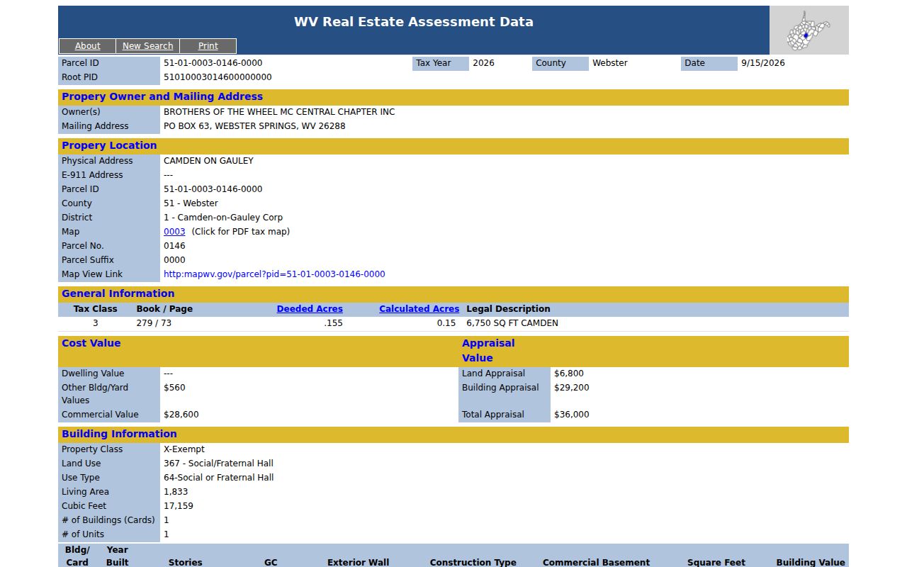
The Camden-on-Gauley IAS detail card shows a Webster County land value, building value, total appraisal, tax class, and recorded deed reference.
Annual Webster County Property Value Updates
County assessors must visit real estate at least once every three years. They also maintain annual market values. Annual updates do not mean a city-by-city trend is published. No Webster Springs, Cowen, or Camden-only time series exists. Use IAS Appraisal/Sales mode to compare parcels by street, map, or land-use fields. Keep each tax year attached to the result.
A January 2026 legal notice described review sessions for the 2025 books. That notice shows the yearly rhythm, not a permanent schedule. A value sometimes needs correcting. Ask the Assessor or Commission about current book and review dates then.
The deadline sequence matters. Land books are finished by January 30. They are submitted to the Board of Equalization and Review by February 1. A specific notice sets the local inspection and meeting dates. Those dates change every year. Save the card and its supporting deed or comparable sale early. Do that before the review period opens. Then confirm the current process with the county.
Find the Webster County Assessed Value
Start with the IAS card for the exact parcel. Search by street name, owner, or full PID. Once the right card opens, record the tax year and the complete identifier. The WV Real Estate Assessment Property Search offers Basic and Appraisal/Sales modes. Filters cover land, building, total appraisal, acres, sale date, and price. Those filters work for any Webster County property search.
- Choose Webster County and search by address, owner, street, or PID.
- Open the detailed card and note the tax year, land appraisal, building appraisal, and total appraisal.
- Read the sales-history date, price, type, source, validity, book, and page fields.
- Use the Clerk index to confirm the recorded conveyance and compare its legal description.
- Appraised value
- The Assessor’s annual market-value estimate for the parcel.
- Assessed value
- The amount after applying the published assessment level.
- Assessment level
- The 60 percent factor used between appraised and assessed values.
- Sale price
- A past transaction amount, which may be old or unlike the current property.
Appraisal/Sales mode has deep filters. Narrow results by land, building, or total appraisal, acreage, sale dates, and prices. Use it to find candidates, not an index. A county-wide figure built from unlike parcels would mislead. An odd result may be a public building, vacant tract, partial-interest transfer, or old transaction, so check the card's class, land use, building details, source, and validity fields before treating it as comparable.
The Fork Lick Webster County Value Example
One sample IAS card for 3291 Webster Road shows why care matters. It lists a total appraisal of $1,100. Sale-history entries show $10,000 in 2009, $5,000 in 1987, and $5,000 in 1986. The card also reports .720 deeded acres but only .27 calculated acres. None say what it would sell for today. They are a reason to inspect the deed reference, the parcel shape, and the sales source fields.
Deeded acres state the quantity named in a conveyance. Calculated acres come from assessor or mapping data. A gap between them can mean two records use different methods or descriptions. Compare the legal description first. Get a survey for any boundary question.
The dates matter as much as the dollars. A $10,000 sale from 2009, flanked by $5,000 entries from 1987 and 1986, is decades old. Never describe such an amount as a current asking price or market estimate. Confirm the sale-history row matches the parcel and legal description now on the card, then follow its book and page reference in the deed records before using it in any comparison.
Camden-on-Gauley Appraisal Fields
A second IAS card in the Camden-on-Gauley corporation district covers a social and fraternal hall. The land appraisal is $6,800. The building, dated 1969, carries an appraisal of $29,200. That brings the total to $36,000 on 0.155 deeded acres. An organization holds the owner of record name. It lists a mailing address in Webster Springs and a physical address in Camden on Gauley.
Read together, the card links the property value, use, and legal district. It is not a sale estimate. It is not a typical home comparison either. Line up nearby cards with care. Keep the physical address, the mailing field, and the corporation district separate from one another.
Recorded Sale Prices in Webster County Cards
Sales history on an IAS card can list date, price, sale type, source code, validity code, book, and page. Think of the row as a lead. The deed is the real instrument. A recorded consideration may cover several parcels or a partial interest. Land acreage may have shifted over time. The deed and its legal description supply the context that a bare price lacks.
Match the parcel and the period when you set a sale beside an assessed value. A price from years back may say little about current conditions. The assessment, by contrast, follows an annual cycle. For a closer look at a transaction, the Webster County property search opens the route to the card. The Clerk's recorded deed backs it up as the supporting instrument.
IAS breaks the sale into separate fields: transaction date, amount, sale type, source, validity, and book and page. Those details hint at the price's meaning. Does it work as a market comparison, or mark a transfer under unusual circumstances? Compare location, land area, building age and size, and use. The deed description matters. It may span multiple lots or a fractional interest. Then the row is not the price of one stand-alone parcel.
Limits of Webster County Property Value Records
An assessor value exists for tax administration. It is not an appraisal for a sale, refinance, or dispute. The figure can diverge from a recorded price. Each reflects a different date, method, or property description. The county publishes no separate Webster County market index. So treat the card as a tax roll record, not a live quote.
Value vs price. The assessed amount is used in the tax formula and is not what a buyer would pay. For a sale opinion, use a qualified appraisal and current transaction evidence.