
How to Search Camden-on-Gauley Property Records
Start your search with the county Assessor's IAS parcel search. Look up a street address or an owner name. Open the card. Note the physical address, mailing address, PID, acreage, legal description, owner of record, and deed book and page. Remember that Camden-on-Gauley property records are really Webster County records. The town has no separate assessor or deed recorder. A mailing city may read Webster Springs even when the parcel sits inside Camden-on-Gauley. Don't toss out a match just because the postal field looks off.
- Search IAS by situs address or owner; keep the full PID and the returned card.
- Compare physical and mailing address fields and check the district, map, parcel, and suffix.
- Use the card’s book/page or owner names in the County Clerk’s land-record index.
- Check the tax information with the Sheriff and use the statewide viewer for geographic context.
- For town permits or zoning, contact the appropriate local custodian; no searchable municipal permit index was located.
The Webster County property search guide walks through the county card, and the deed records page shows how to follow a recorded reference. When an address will not resolve, the parcel number and deed description anchor the search better than any town or postal label.
County Records and Camden-on-Gauley Contacts
Four county offices divide the work. The County Clerk records deeds, liens, releases, and plats. The Assessor maintains parcel characteristics and appraisal data. The Sheriff handles tax billing and collection, while the Circuit Clerk holds court records. All of them serve Camden-on-Gauley parcels from the Webster County courthouse. The state's local-government page lists town contacts, but the town itself publishes no separate property search, assessor, or permit database.
Webster County Property Records
Use county systems for the deed trail, assessment card, tax bill, and parcel mapping.
Camden-on-Gauley Government
Use the state local-government directory to route municipal questions.
Street address and direct phone were not located in the reviewed sources.
Camden-on-Gauley Locality Clues in Parcel Records
No Camden subdivision roster, town plat index, annexation map, or town-only parcel-number range exists in these records. That absence matters. An address label or a nearby landmark is not a subdivision name. Inventing one only muddies a title search. Search the exact situs address or a known owner instead, then rely on the legal description and the recorded plat citation on the tax card to pin down the parcel's identity in the county records.
| Clue | Verified record detail | Search use |
|---|---|---|
| Camden-on-Gauley | Town-place label; 2020 population 126 | Use as a locality term, then confirm the card and boundary. |
| Webster Springs | May appear as a parcel’s mailing city | Keep mailing city separate from physical parcel location. |
| District 1, map 0003 | Shown on the reviewed Camden parcel card | Use as a search clue for that card only, not a townwide range. |
The parcel map guide shows how the county map key fits into a search. For any other Camden property, verify its own district and map numbers rather than borrowing one parcel's identifier for the whole town.
A Small Incorporated Place with Countywide Records
The 2020 Census counted 126 residents in Camden-on-Gauley. That figure describes the incorporated place at census time. It is not a parcel count or a current boundary survey. Even a town this small can hold a mix. Residential, community, and commercial parcels all appear in the county tax roll. The town keeps no land-record index of its own. An owner, buyer, or researcher follows the same county record chain used everywhere else in Webster County. Want to confirm whether a tract sits inside the municipal boundary? Ask the town or county for an authoritative map. The assessment card and postal address alone cannot settle that jurisdictional question.
The West Virginia local-government page for Camden-on-Gauley is the reviewed source for routing a town-level question.
Why the Mailing City May Say Webster Springs
One Camden-on-Gauley parcel card shows how the two address fields differ. The physical place reads Camden-on-Gauley. Yet the owner's mailing address is a Webster Springs post office box. Those fields do different jobs. The situs identifies the property; the mailing line routes tax bills and correspondence. Nothing about the postal label moves the parcel into Webster Springs. In a search, try the situs address first. If you already have the card, record both address values in your notes. Then pull it up again with the owner name or full parcel number. Mail returned to a wrong address is an administrative problem. The Assessor or Sheriff can fix it. It is not evidence of a different parcel location.
Read the Verified Camden Parcel Card Carefully
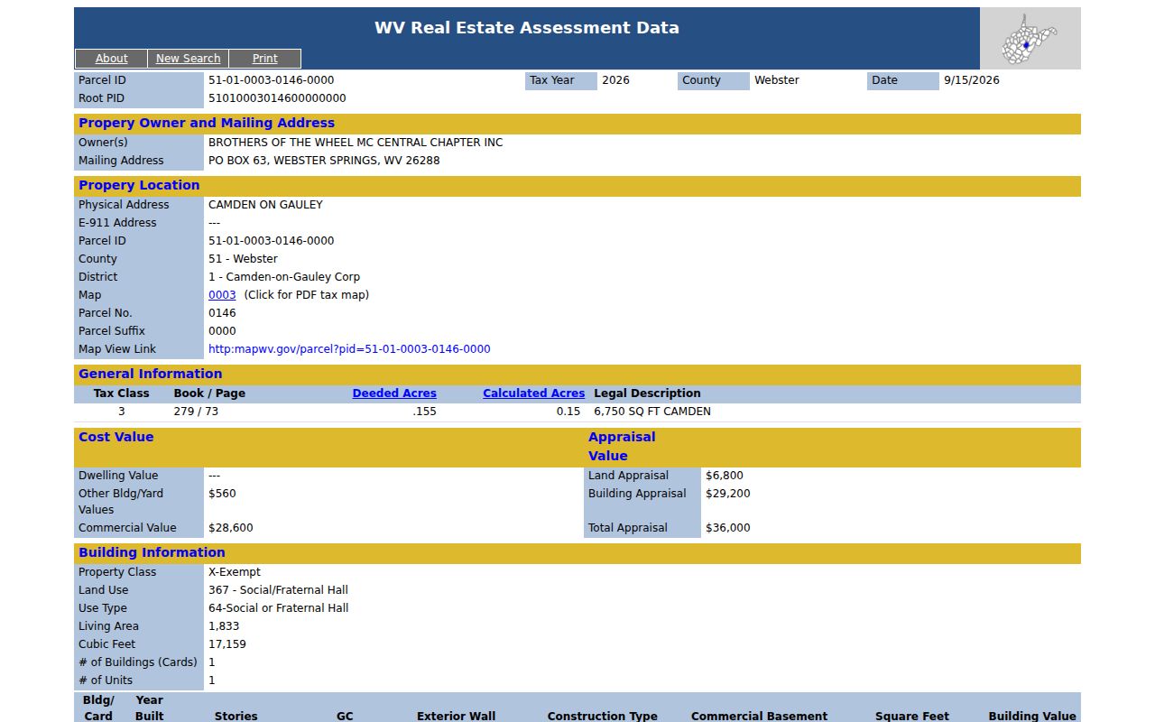
One IAS card from Camden-on-Gauley lists Brothers of the Wheel MC Central Chapter Inc. as owner. The property is a social and fraternal hall. Tax class 3 applies. The building measures 1,833 square feet and dates to 1969, on 0.155 deeded acres. Its appraisal breaks down as $6,800 for land and $29,200 for the building, totaling $36,000. Fields like these appear on any individual card. This one is not a typical Camden home value, though, or a current sale estimate. The card also gives district 1, map 0003, parcel 0146, suffix 0000. The full PID is rendered as `51-01-0003-0146-0000`. Its legal description notes 6,750 square feet. Its deed reference is book 279, page 73. Keep the leading zeroes and punctuation intact when you copy the identifier. Before treating the card as a complete chain of title, confirm the instrument in the Clerk's deed index.
The Webster County assessment system provides the parcel card fields shown in this Camden example.
Camden PID Components and Deed References
The sample identifier starts with county code 51. District 01 follows, then map 0003, parcel 0146, and suffix 0000. The district is separate from the county code. Keeping that distinction straight prevents misreads. Copy a PID from a card into a map or search field with care. Other properties carry different map values. Use the actual card rather than extrapolating from this example. The same card's book/page reference, 279/73, opens a second route to the recorded instrument. Search the owner names and instrument date in the Clerk's indexed land records. Then compare the deed's legal description against the current parcel card. That cross-check earns its keep. A deed may describe a tract by acreage or metes and bounds rather than by street number.
Understanding the $36,000 Assessment Example
That $36,000 figure on the Camden card is an appraisal, not a market price. It covers land and a community building. The Assessor sets annual market values from property characteristics and local evidence. A 60 percent ratio then produces assessed value. The levy applies last. Tax is calculated on assessed value. So a tax bill, an appraisal, and a private sale price each answer a different question.
Camden-on-Gauley publishes no townwide median or value trend. Compare similar uses and physical characteristics instead, and study actual sale history where it exists. If the card's square footage, acreage, use, or condition looks wrong, contact the Assessor and ask about the property review process rather than borrowing another parcel's figure.
County Tax Timing and Ownership Changes
West Virginia’s assessment calendar can leave a recent conveyance and the name on the current tax material temporarily out of sync. The Clerk sends transfer information to the Assessor by the tenth of each month, but the supplied research provides no guaranteed online update interval. A 2022 bill, for example, reflected ownership on July 1, 2021. If a Camden parcel changed hands after that date, check the deed and ask the Assessor which card year is being viewed.
Tax questions go to the Sheriff, while valuation or card corrections go to the Assessor. Before an annual review deadline, confirm the current Board of Review and Equalization schedule directly with the county; an archived notice is not a current appointment calendar. This is especially important when a parcel’s use or improvement data, rather than just the owner name, is disputed.
What Camden-on-Gauley Property Records Can Confirm
The Webster County record trail answers several questions at once. It shows the owner of record reported on the card. It also gives the recorded deed reference, parcel characteristics, and tax values. An approximate mapped location is included too. A Camden-on-Gauley town contact can field municipal questions. The town publishes no online permit index. These property records cannot prove market value, physical condition, legal access, or a survey boundary. They cannot prove marketable title.
For a serious transaction or boundary dispute, read the deed. Then inspect the actual tax map. Use a qualified surveyor or attorney as appropriate. Under the West Virginia Freedom of Information Act, request identifiable public records with reasonable specificity. Expect permissible copy charges. Keep owner contact data private. Use it only for a legitimate property or civic purpose.
Lawful use. Camden-on-Gauley property records support ownership research, due diligence, and civic transparency. Do not use personal or parcel information to stalk, harass, threaten, or harm anyone.