
Search Addison Property Records by Address
Start with the county systems outlined on the Webster County property search page. For the county seat, search both Addison and Webster Springs. Use the second name if the first place name fails. The IAS parcel card anchors any lookup. Open it, copy the PID, and keep the deed reference. The County Clerk index then points to the recorded instrument. The Sheriff sends the tax bill. The statewide viewer helps place the parcel and find nearby lots.
No separate Addison assessor or town recorder exists. An assessor card can show a building's recorded features. It is not a permit history, though. Permits and zoning files sit with a different local custodian. Ask that office directly, by address and approximate year.
- Try the street address under Addison and Webster Springs in the WV IAS search.
- Save the owner field, full PID, physical address, legal description, and deed book/page.
- Check the County Clerk index for the deed or plat tied to the parcel.
- Use the viewer for map context, then call the Sheriff about a bill or tax status.
- Request local permit or zoning records by street and approximate work year; no public municipal search was located.
Keep the town name, postal city, district, and parcel ID in separate notes. That simple habit pays off. It stops a Webster Springs mailing address from being treated as proof that a tract lies inside the incorporated place.
Where Webster County Keeps Addison Records
Four county offices split the work. The County Clerk records Addison deeds, plats, and liens. The Assessor holds the tax parcels. The Sheriff collects the tax, and the Circuit Clerk handles property litigation. All four work from the courthouse in Webster Springs. Permits and zoning follow a separate town route, and no online municipal permit database exists for Addison or Webster Springs.
Webster County Property Records
The Clerk, Assessor, Sheriff, and Circuit Clerk hold the county record trail for Addison parcels.
Addison / Webster Springs Permits
No public town permit or zoning search was located.
Request by street address and approximate work year.
Confirm the local custodian by phone
Town Lots and Localities in Addison Records
Local record material names the Webster Springs town lots and the courthouse and springs area at the town's center. Nearby communities and landmarks appear too. Those are locality clues, though. No official subdivision index or plat-name list is published, so treat them as leads rather than verified subdivision names.
| Neighborhood / Subdivision | Era | In the Records |
|---|---|---|
| Webster Springs town lots | Plat era not located | Search Clerk plat categories and confirm the lot description in a deed. |
| Courthouse and springs area | Town subdivision dates not verified | Use a current parcel ID and recorded legal description; do not infer a plat name. |
| Bolair, Upperglade, Diana, Cleveland, Hacker Valley, Bergoo | Community and landmark clues, not verified subdivisions | Use locality terms to find a district or map, then confirm the tract. |
For a town lot, start with the current parcel. Search it by street or owner, and copy the PID. Then compare the Clerk's plat against the deed description. The Webster County parcel maps page explains the district and map key. Nearby community names can be useful leads. But they do not prove land lies inside Addison's town limits.
Addison and Webster Springs in the Record
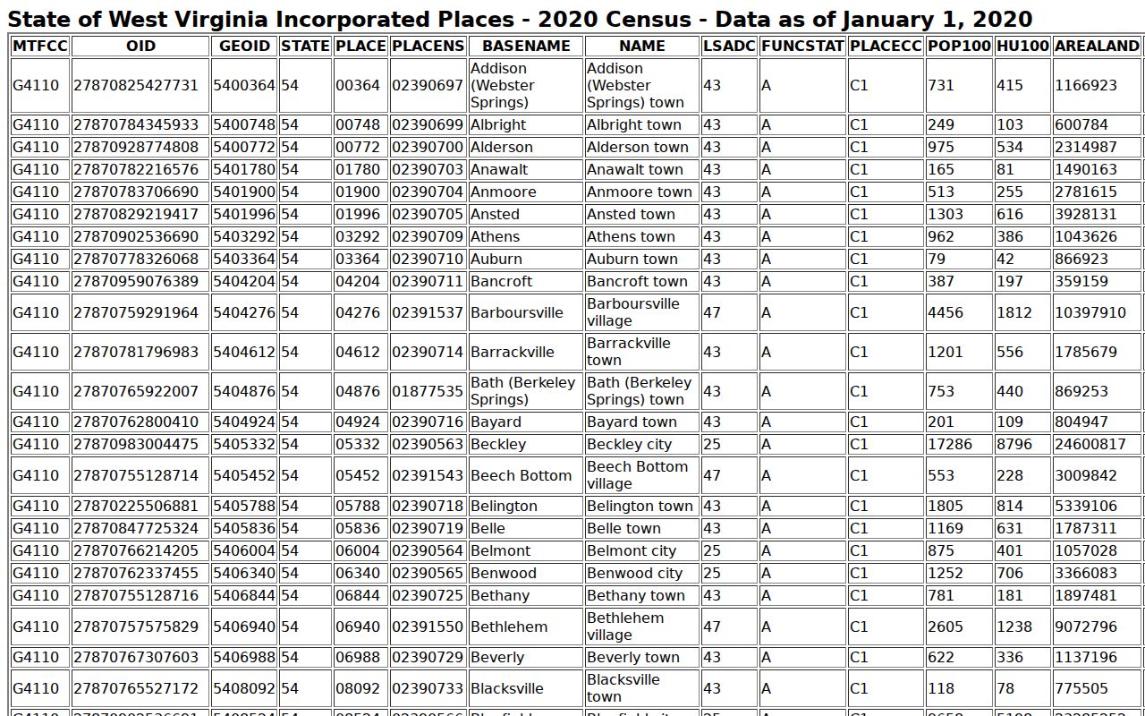
Both names matter here. The Census place roster lists "Addison (Webster Springs)." The courthouse says Webster Springs. The postal address and current civic references generally say Webster Springs too. That legal-name and postal-name split is the county seat's main search quirk. A historic deed or plat may still say Addison. A map, tax card, and district label can connect the two references.
The 2020 Census place material reports 731 residents. It reports 415 housing units for Addison (Webster Springs). Those figures identify the incorporated place in that census year. They do not define today's delivery area or parcel count. Preserve the source name and year in any local property note.
The Census incorporated-place table records Addison (Webster Springs) as the county seat’s legal place name.
The Four-Room Webster Springs Courthouse
Everything county-held sits under one roof at 2 Court Square in Webster Springs. That includes the offices an Addison researcher needs most. The County Clerk works from Room G1. The Assessor is in G2, the Sheriff in G3, and the Circuit Clerk in G4. Public hours run 8:30 a.m. to 4:00 p.m., though each counter may keep its own schedule. A quick phone call settles it.
Because Addison serves as the county seat, its property records live here as county records rather than town holdings. Land, tax, and court files all share the building. One caution applies. Zoning and permit papers may rest with a different custodian entirely. Ask which office holds a given file before ordering a copy. An assessor building card, for instance, is not a permit history.
Webster Springs Addresses and Parcel IDs
Addison property records use the statewide parcel key: county code, district, map, and parcel. A suffix completes the key. The tax-card district beats a ZIP as a city locator. No complete Addison-only map prefix is published for Webster County. Lettered map labels can occur. One sample card, 007Q, comes from Fork Lick. That is not an Addison parcel range.
Keep the full PID as printed, with its leading zeroes. Compare the physical address against the separate E-911 field. Check the mailing field too. The state viewer's E-911 search rejects rural routes. It also rejects PO boxes. If the address search fails, use owner, street, or PID in IAS. Then return to the map.
ZIP 26288 Does Not Mark Addison Limits
The courthouse carries a Webster Springs 26288 mailing address. That ZIP serves as the principal postal code for the county-seat community. It is not a boundary. Nearby communities fall under other Webster County ZIPs. Postal delivery routes regularly cross municipal lines. No Addison-specific ZIP or PO-box-only assignment appears in the official postal data. The USPS publishes no precise outline of the incorporated place either.
The USPS ZIP Code Lookup can settle delivery questions for a given address. Treat the postal label as a convenience only. A property listed under Webster Springs 26288 can still sit outside the municipal limit. For a clearer answer, look at the parcel's district and legal description together. The county PID often reveals more about jurisdiction than the mailing city does.
For a parcel near the edge of Addison, pull the official place boundary. Compare it with the county parcel number. Then ask the local custodian to confirm which jurisdiction holds the property. Confirming jurisdiction through property records beats trusting a postal city name every time.
Permits and Zoning for Addison Properties
Webster Springs offers no public online permit search. To trace a house's work history, request permits by street address and approximate year. The town or county custodian handles those requests. Then compare what you receive against the Assessor's building card. Ask where the file is held. It may sit with municipal, county, or state offices, so confirm which one keeps it. Also ask what retention and copy rules govern it. Keep expectations realistic. A missing permit result never proves that work did not happen.
No published fee schedule, permit form, or zoning case database exists at the local level. Start instead with the county courthouse contact information. Ask which official keeps the file you need. Spell out the address and the type of work. Include any known owner or applicant and the date span. The more specific the request, the better the property records search goes. A precise ask often surfaces records that a general inquiry would miss.
Webster Springs Values Follow the County Cycle
Values in Webster Springs follow the county's calendar. The Assessor maintains market values annually, visits each parcel at least once every three years, and applies the statewide 60 percent assessment level. County materials publish no Webster Springs-only value trend. No fast-appreciating district gets named either. Use the IAS Appraisal/Sales mode with a street or map filter for parcel-level appraisal data. Record the tax year, the land and building split, and any sale references for each parcel.
A 2026 Board of Equalization notice illustrates the annual review path. It is not a city-specific revaluation report. Confirm the current assessment and review calendar with the Assessor or the Commission. And remember what an appraisal is not. A mailing ZIP, a recent renovation, or a nearby sale alone never establishes a parcel's assessed value in the county tax roll.
Older Addison Deeds and the 1888 Fire
Fire shaped Addison's early deed records. The state archive finding aid notes that the courthouse burned in 1888. Surviving Webster deed books run from 1877 through 1902. A deed index covers 1888 through 1969. Land-entry plats span 1860 through 1990. An older deed may name Addison itself, a vanished district, or a town lot rather than a current Webster Springs street. Preserve that original wording while you trace the title.
When the online land-record page returns nothing, or an image is missing, take the search offline. Ask the County Clerk about older books. Consult the archive inventory as well. Wills and fiduciary records sometimes explain a transfer that never passed through a normal sale. An empty online result is simply not a complete historical search of Webster County property records.
The archive inventory shines when a street-based search cannot reach a town lot described by older district or landmark names. Copy every book, page, map, and plat reference into your notes. Keep the instrument's original place-name spelling intact. A modern tax parcel may link back to an older deed. Only the legal description can prove that connection.
What Addison Property Records Can Establish
Addison property records document a great deal. They cover county assessments, recorded transfers, parcel geography, taxes, and court filings. They cannot establish a current market price. They do not prove a survey line or show who occupies a building. City permits may sit outside county systems. No public portal offers them. When the parcel itself is in dispute, compare the original deeds and plats directly.
Lawful use. Use the public record for property history, tax review, boundaries, and civic questions. Do not use an owner’s name or address to stalk, harass, threaten, or expose anyone.