
Webster County Property Search Steps
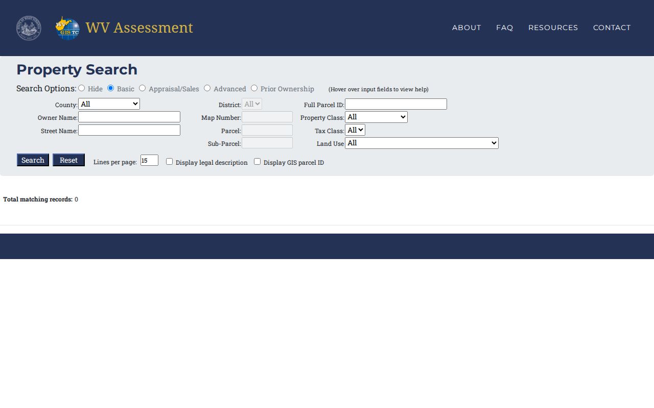
West Virginia's Real Estate Assessment search is commonly called IAS. It is the strongest first stop when you already have a Webster County parcel in mind. The form takes a county and district, an owner name, a street name, a map or parcel segment, or a full parcel ID. An address feels natural. But rural routes, post-office boxes, old place names, and vacant tracts often fail to resolve. If you know an owner of record, try spelling variants and business names too. A full PID is the best match once you hold it.
Carry one stable key from the assessor result into every other system. The Owner(s) field, physical address, district, map, parcel, suffix, and deed book and page all matter here. Each of these details helps tie an IAS card to the clerk's deed records. Treat any result as a starting record rather than a title opinion. Compare the current entry against the newest recorded instrument in Webster County.
- Choose Webster County and search by address, owner, street, or PID in the WV Real Estate Assessment Property Search.
- Open the matching parcel card and note its complete PID, physical address, owner field, tax year, and deed book/page.
- Use the owner name or book/page in the Webster County indexed land-record portal to find the recorded instrument.
- Check the WV Property Viewer for location and nearby parcels, then ask the Sheriff about a bill or delinquency.
- For a certified or older copy, ask the County Clerk which book, image, or counter process applies; fees and online image coverage are not posted on the county portal page.
WV IAS Fields for Webster County Property Search
The IAS form offers Basic, Appraisal/Sales, Advanced, and Prior Ownership modes. Its labels appear below as the form presents them. The portal publishes no index cutoff, result cap, or exact-match rules. Keep your query details handy when repeating a search.
Basic mode handles the practical first pass. It covers county, district, PID, owner, map, parcel, and street. Appraisal/Sales narrows results by land, building, and total appraisal. It also filters by acreage, sale date, and sale price. Advanced mode adds property and tax class. It also covers land use, building year or area, structure counts, and flood hazard. Prior Ownership helps trace earlier names in Webster County. But an online result is only an index lead. Confirm every conveyance in the recorded deed itself.
| IAS field | What to enter | Useful note |
|---|---|---|
| County, District | Select a county and local district | Start with Webster County; district names narrow the set. |
| Full Parcel ID | Complete PID, with or without hyphens | Keep map letters and leading zeroes. |
| Owner Name | Person or entity name | Try initials, spelling forms, and LLC names. |
| Map Number, Parcel, Sub-Parcel | Parcel components | The Webster sample map includes the lettered value 007Q. |
| Street Name | Road or street text | Useful for a block search; matching rules are not stated. |
| Property Class, Tax Class, Land Use | Dropdown filters | Use these to narrow a large result set. |
| Land, Building, Total Appraisal | Minimum and maximum values | Available in Appraisal/Sales and Advanced modes. |
| Calculated or Deeded Acres | Minimum and maximum acreage | Both measures can differ on the same card. |
| Sale From / Through, Price | Date and price ranges | Filters recorded sale-history entries. |
| Mailing Address | Owner correspondence text | It is separate from the physical property address. |
| Deed Book, Page, Legal Description | Reference or description text | Use these to connect the card with clerk records. |
| Building Year, Area, Structures | Ranges and structure counts | Advanced mode includes building and structure filters. |
| Flood Hazard | Dropdown filter | A card also links to the WV Flood Tool. |
| Lines per page and display toggles | Result display options | Can show the legal description or GIS parcel ID. |
Results can be sent to the WV Property Viewer for a map display. The assessor form states no result limit and no fixed coverage date. So a failed search never proves the parcel is missing. Try another key, then contact the Assessor in Room G2.
Display options such as lines per page, a legal description, or a GIS parcel ID change how results look. They do not change what they prove. For a solid research log, record the date. Note the county and district filters, exact spelling, search mode, and the PID of any match. That way a repeat search can tell a genuinely new card from a different query. The search help publishes no rules about partial-word matching or punctuation, so assume nothing there. Work the keys in Webster County rather than trusting one attempt.
Address Names in Webster County Property Search
Webster Springs is both the county seat and the postal name. Census and legal materials call the town Addison. A historic deed, plat, tax map, or address index may use either name. Search both spellings when a town address will not appear. Hold the district, map, parcel, and suffix steady as your cross-reference.
Address search also leans on the statewide E-911/SAMS source. The WV Property Viewer accepts a street address, city, and state abbreviation. A rural route or post-office box will not work there. Rural property in Webster County is still findable by owner or parcel in IAS. A street-name query may return several parcels rather than one house. That suits a block review. It still demands a careful read of physical addresses and legal descriptions.
What a Webster County Parcel Card Reveals
The detailed IAS card offers far more than an owner-name match. It joins the tax parcel to a location, a legal description, valuation fields, structure facts, and sales references. Copy the Owner(s) label exactly as displayed, and read the mailing and physical addresses as two separate fields on the parcel record.
| Owner(s) and mailing address | Name on the tax card and the address used for correspondence. |
|---|---|
| Physical / E-911 address | Situs details; the two address fields may differ or one may be blank. |
| Parcel ID and district | County, district, map, parcel, and suffix identify the tax parcel. |
| Deed reference and acreage | Book/page, deeded acres, calculated acres, and legal description. |
| Appraisal and building | Land, building, dwelling, other improvements, total appraisal, and structure details. |
| Flood and sales history | Flood fields and sale date, price, type, source, validity, book, and page. |
A sample card for 3291 Webster Road shows why these fields belong together. The owner is Jordan's Land & Rentals LLC, the situs is Webster Road, the district is Fork Lick, and the map is 007Q. It lists .720 deeded acres against .27 calculated acres. It also shows a $1,100 total appraisal. Earlier sale entries show $10,000 in 2009 and $5,000 in both 1987 and 1986. None of that is a current market quote. The gaps call for deed records and parcel context. Judge the property's value in Webster County only after that.
The WV assessment search shows the county, owner, street, parcel, and appraisal filters used for a Webster County property search.
Owner and Mailing Clues on Webster County Records
Names make a shaky search key in Webster County property records. One owner can hold several parcels under different spellings. Estates, trusts, LLCs, fraternal groups, and common personal names cause trouble. Each often appears in more than one form. When an entity owns the land, the Secretary of State's WV Business Entity Search can help. It shows the entity's type, status, address, creation date, and registered agent. Viewing the entity record is free, and a certificate costs $10.
The two addresses on a parcel card answer different questions. The mailing address shows where the Assessor sends notices. The physical address shows where the parcel sits. A Camden-on-Gauley card may carry a Camden physical address. Its mailing address can still be Webster Springs. Postal city is not the legal municipality. Compare the district label and legal description. Then use the map or a clerk plat to settle the location.
From a Webster County Search to the Deed
A parcel card often carries a deed book and page. Take that citation to the Clerk's indexed land records. The index lists deeds, deeds of trust, liens, releases, plats, assignments, agreements, and affidavits. It also lists foreclosure trustee reports. No complete online image range, account rule, or fee schedule appears on the public landing page. If an image is missing, ask the Clerk about the record. It may sit in a book, a vault, or a separate archive.
The deed itself confirms the grantor, grantee, legal description, and recording reference. A card's sales history is only a lead. It is not the instrument. The Webster County deed-records page covers index categories and older books. The mapping and tax pages cover their own records.
Some parcels carry more than one address field. Keep the physical situs and E-911 text apart from the mailing destination. A result may show both deeded and calculated acreage. Save both numbers. Compare the deed or plat before treating either figure as a boundary measurement. The detailed record also lists building characteristics and flood information. Those fields describe the assessor's record, not a permit, inspection, or flood-insurance determination.
When a Webster County Property Search Fails
A failed address search has plenty of fallbacks in Webster County. Try the owner, street name, PID, map, or legal-description field instead. The county seat appears under both Addison and Webster Springs. Search both spellings. Confirm leading zeroes and any lettered map value. A value like 007Q is easy to mistype. If the statewide viewer cannot match a rural route or PO box, return to IAS and search by owner or parcel key.
Some land records never reach the internet. Call the Webster County Clerk at 304-847-2508 or visit Room G1 at 2 Court Square. Listed courthouse hours run 8:30 a.m. to 4:00 p.m. Confirm counter hours by phone. West Virginia FOIA permits a specific written request for a clearly described public record. Name the office, record, parcel or address, date span, and preferred format. Copy costs may apply, but the statute bars search or retrieval fees.
Keep a trail of each attempt. Save the exact owner spelling, street wording, county and district, selected mode, and query date. An LLC result deserves a check of its full filed name in the state business registry. An estate result points elsewhere. Follow probate and the recorded conveyance. Those notes make a repeat visit far more useful. They also help an Assessor or Clerk separate your parcel from a similarly named tract.
Search by Address, Owner, or Parcel
Address search is fastest with a known situs. Owner search fills the gaps. It works when a road number changed or a parcel lacks a street address. Once a card is identified, the PID becomes the most precise key. IAS keeps physical and mailing fields separate. Use the situs, not the tax-notice destination, to locate the land. A Clerk index search may need a grantor or grantee name. An address may not work there.
| Search Key | Best For | Where It Works | Watch Out |
|---|---|---|---|
| Address | A known house or business location | Assessor IAS and statewide viewer | Rural routes, renamed roads, and mailing-only addresses |
| Owner name | Properties under a person or entity | Assessor IAS; grantor/grantee index | Trusts, LLCs, estates, spelling variants, and common names |
| Parcel number | Exact match across tax and map records | Assessor, Sheriff, and parcel viewer | Keep county, district, map, parcel, suffix, zeroes, and letters intact |
Not a title search. A Webster County property search reports indexed and assessed information; it does not guarantee clear title or resolve competing claims. Ask a title professional or attorney to examine the chain of title.