
How to Find Webster County Property Records
No master database holds all Webster County property records. The Assessor's IAS parcel card links an owner of record to a value. The County Clerk indexes deeds, liens, releases, plats, and probate papers. The Sheriff collects taxes and tracks delinquency. The Circuit Clerk holds property litigation files. A state property viewer supplies the GIS map and neighboring parcels. Match your question to the right record first. Then use its parcel ID, book and page, or legal description to pull the next source.
An address works as a first key for most houses and tracts. It fails with rural routes, PO boxes, old names, or a missing E-911 match, and an owner or full PID works better there. Keep the roles straight too. The deed controls the recorded transfer, the tax card describes the assessment, and a surveyor settles a boundary. None of them replaces the others.
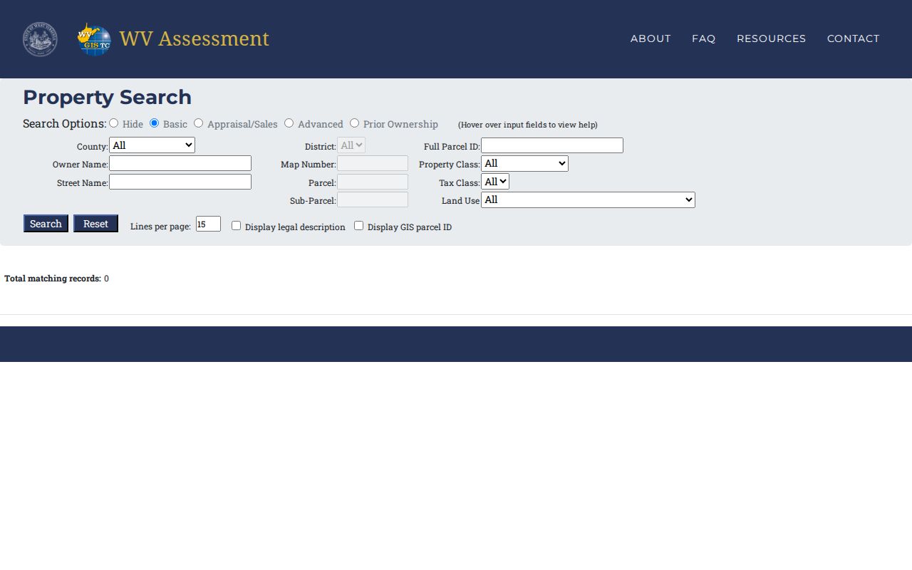
- Search the WV Real Estate Assessment Property Search by street, owner, or PID.
- Save the full parcel ID, `Owner(s)`, mailing address, legal description, and deed reference.
- Use the book/page or party name in the Webster County Clerk’s land-record index.
- Ask the Sheriff about the current bill or delinquency, and use the viewer to locate nearby parcels.
- For older books or certified copies, contact the custodian or search the state archive finding aid.
Offices That Keep Webster County Property Records
Four offices sit at 2 Court Square in Webster Springs, one room for each stage of the county property trail. The courthouse directory lists public hours from 8:30 a.m. to 4:00 p.m., though a specific counter may keep its own schedule. A quick call before traveling is wise. Title, value, tax, and litigation questions each belong to a different desk.
Room and phone details for routing a request: County Clerk in G1 at 304-847-2508, Assessor in G2 at 304-847-2110, Sheriff in G3 at 304-847-2006, and Circuit Clerk in G4 at 304-847-2421. Call ahead before asking for a deed book, tax file, or court case. The building is only the access point. Each office keeps its own records and copy process.
Webster County Clerk, Room G1
2 Court Square, Webster Springs, WV 26288
304-847-2508
Webster County Assessor, Room G2
2 Court Square, Webster Springs, WV 26288
304-847-2110
Webster County Sheriff, Room G3
2 Court Square, Webster Springs, WV 26288
304-847-2006
Webster Circuit Clerk, Room G4
2 Court Square, Webster Springs, WV 26288
304-847-2421
The County Clerk answers questions about what was signed and recorded. The Assessor maintains the parcel card, the reported owner, physical characteristics, and the annual appraisal. Ask the Sheriff whether a tax bill was paid or a balance remains. The Circuit Clerk can point the way on a court-file inquiry, and statewide online court coverage should be checked for the case type and year. Keeping these roles distinct matters. An assessed owner field is not a deed. A GIS outline is not a court finding.
Start with the IAS Owner(s) Field
The detailed assessment card labels its ownership field `Owner(s)`. It also separates `Mailing Address`, `Physical Address`, and `E-911 Address`. Then it lists the PID, tax class, deed book and page, acres, appraisal, building details, flood data, and sale history. Read the card as joined fields, not one owner line. A map summary may show a single name, but the full IAS detail may reveal multiple owners. Open the detail view.
One sample card for 3291 Webster Road shows how this works. It names Jordan's Land & Rentals LLC with a Richmond, Virginia mailing address. It gives Fork Lick district, map 007Q, parcel 0038. The card lists .720 deeded acres against .27 calculated acres. That gap is a useful warning. Carry the legal description and parcel key forward instead of trusting an address alone.
The West Virginia assessment search is the starting point for Webster County owner, street, parcel, tax-class, and appraisal queries.
Why Addison Appears as Webster Springs
The county seat answers to two names. That split trips up both old and new searches. Census and legal materials call the incorporated town Addison. Postal and civic sources use Webster Springs. A deed, plat, census entry, tax map, or address index may carry either label. Run both strings when an address search stalls. The district, map, parcel, and suffix form the stable key.
The postal name says nothing about municipal limits, though. ZIP geography can cross a town line. No complete USPS boundary or PO-box assignment list exists here. Confirm town location through a parcel record or official place boundary instead of guessing from a mailing address.
Record Types in Webster County Property Records
A conveyance, a tax assessment, a payment, a map, and a court file all connect within Webster County property records, yet each document has its own custodian and its own limits. This map points to the right first source and the next check when a question crosses record types.
| Record Type | What It Documents | Kept By | Access |
|---|---|---|---|
| Deeds and land instruments | Transfers, deeds of trust, liens, releases, assignments, affidavits, and plats. | County Clerk | Indexed portal, Clerk counter, and older books. |
| Assessment cards | Owner(s), situs and mailing, tax class, appraisal, buildings, acreage, and sale history. | County Assessor | WV IAS search, local guidance, or Room G2. |
| Tax bills and delinquencies | Current collection status and delinquent-tax enforcement. | County Sheriff | Ask Room G3; no dedicated public bill URL was located. |
| Parcel maps and plats | Parcel location, ID, lot layout, and nearby parcels. | WV Property Viewer, County GIS, Clerk | Free viewers; recorded plat or survey for legal boundary questions. |
| Property litigation | Foreclosure, quiet title, partition, lis pendens, judgments, and related cases. | Circuit Clerk and courts | State court search, then Room G4 for files not online. |
| Permits and zoning | Local building or land-use history where a town retains it. | Town custodian | No public municipal permit lookup was located for the three towns. |
Ownership questions start with the Clerk's deed records. Value lives in the Assessor's field card and tax year. The Sheriff handles the bill. GIS places the parcel against its neighbors before a return trip to the assessment card. For municipal work history, call the relevant town and ask whether the record exists. The county card is not a permit file.
A property search can surface Clerk recordings that are not deeds. Deeds of trust secure an obligation. Releases record that a claim was discharged. Assignments move an interest to another party. Affidavits and agreements may add facts or terms, while plats depict a lot arrangement. Liens and foreclosure trustee reports can affect a tract. They do not change the assessor's owner field right away. Read the instrument and its recording stamp before deciding what it establishes.
Historical access has limits of its own. The courthouse burned in 1888. The archive finding aid lists deed books for 1877 through 1902. It also lists a deed index covering 1888 through 1969, and land-entry plats spanning 1860 through 1990. Those archive ranges are research aids rather than a promise that every original survives or that the online portal covers the same years. So for a gap ask the Clerk and check the archive collection description.
From Webster County PID to Recorded Plat
The parcel key ties tax and map systems together. A Webster County example reads `51-03-007Q-0038-0000`. The pieces break out cleanly: county code 51, district 03, lettered map 007Q, parcel 0038, suffix 0000. Keep the zeroes. Keep the letter. A legal description may rely on a lot and block, acreage, metes and bounds, or a road or stream reference. So the PID is a way to find the source, not a substitute for it.
The County Clerk indexes plat maps. The archive lists a Record of Entries & Plats of Land covering 1860 through 1990. Compare a recorded plat with the deed whenever a boundary line, lot, or shared access matters. Assessor maps serve taxation only. They can drop a building onto a neighboring polygon. Neither layer proves a legal boundary.
Webster County Deeds After the 1888 Fire
Older deed research in Webster County hits one hard fact. The courthouse burned in 1888. The state archive finding aid lists deed books from 1877 through 1902, an index to deeds covering 1888 through 1969, wills from 1888 through 1964, and land-entry plats from 1860 through 1990. Those ranges are what the archive holds. A missing early entry may reflect the record's survival, not a missing transaction.
For a long chain, work the current deed's grantor backward through the grantor-grantee index. When the online entry stops, try the archive inventory. Ask the Clerk about the vault or microfilm. Preserve old district terms such as Fork Lick, Glade, Holly, and Hacker Valley. Those old terms can tie a tract to a later district label.
July 1 and the Webster County Assessment Roll
The Webster County Assessor maintains annual market values. The office must visit real estate at least once every three years. Land and personal-property books close by January 30. They reach the Board of Equalization and Review by February 1. July 1 is the hinge. The local example says 2022 taxes reflect what was owned on July 1, 2021. A deed recorded later can be newer than the owner name on the roll.
West Virginia Code §11-4-8 requires the Clerk to send title-transfer lists to the Assessor. The deadline is the tenth day of each month. The county publishes no average update lag. For a recent sale, compare dates. Match the deed recording date against the tax year. Ask the Assessor when the roll will catch up. Do so if the owner of record still shows the prior deed.
Use Webster County GIS to See the Block
The WV Property Viewer handles several search types. These include E-911 address, parcel attribute, full PID, buffered geometry, and coordinate searches. It can identify adjacent parcel IDs. A CSV export control exists, though the exact columns and result cap are unstated. Zoom until the outlines display. Then open each neighboring PID in IAS and compare the detailed owner fields.
The state viewer pulls addresses from SAMS. Owner and parcel data come from IAS. It will not take rural routes or PO boxes as E-911 searches. Its summary owner may show only one name. The county ArcGIS disclaimer calls the map informational. It is not a survey, appraisal, zoning verification, or title search.
Tax Bills and Court Files in Webster County
The Webster County Sheriff collects state, county, municipal, and school taxes and enforces delinquent taxes. The county posts no online bill page. No delinquent-land list appears online either. Use the parcel ID when you ask about current bill status. Check the Clerk for a tax-related notice or deed, since a tax card alone cannot show whether a bill was paid.
Property disputes can also land in Circuit 17. The judiciary offers online circuit civil and criminal records back to 1999, with magistrate electronic access beginning in 2024. Confirm the current search coverage. Ask the Circuit Clerk for older or unavailable files. A docket explains a case but never replaces a recorded instrument.
When Webster County Online Records Stop
Some Webster County property records never make it online. When that happens, visit the office that holds the record or send a focused written request. West Virginia FOIA, under W. Va. Code chapter 29B and §29B-1-3, asks for reasonable specificity. The custodian must respond as soon as practicable and within five days, weekends and legal holidays excluded. Reproduction costs can be charged. Search and retrieval fees cannot. A strong request names the office, the record type, an address or parcel number, the date span, a book and page if known, and your preferred format. Courthouse work often moves from the Clerk to the Assessor, the Sheriff, and the Circuit Clerk inside one building. For historic material, the state archive finding aid lists microfilm runs.
Limits of Webster County Property Records
Public property records show what an office received, assessed, mapped, or docketed. Nothing more. They do not guarantee clear title. They do not prove a boundary, set a current sale price, or name everyone connected to a property. A map is not a survey. A tax card is not the deed. A court result is not the recorded transfer. When one source conflicts with another, compare the original instrument. Ask the custodian to explain the field or filing. Each record serves one purpose. A deed records a legal instrument. An assessment card supports taxation. A Sheriff account tracks collection. A parcel layer supplies map context. Keep both references when records disagree. Ask the office that created the field to explain it. For a document that is not online, request it directly. Name the office, record type, parcel or address, and date span. The state FOIA framework allows reproduction costs but bars search and retrieval fees. A practical transaction review starts with the IAS card. Then follow the deed book and page to the Clerk. Use the parcel number to check the map. Compare the tax year next, and ask the Sheriff about the bill. If a boundary matters, read the recorded plat and have a surveyor locate it. For a family transfer, add the probate file. This sequence relies on the county's actual custodians. It avoids assuming one online result answers every question about a property.
Lawful use. Webster County records support property research, estate work, purchase due diligence, tax review, and civic transparency. Do not use owner names or addresses to stalk, harass, threaten, or harm a person. A title professional and licensed surveyor handle questions that public search pages cannot resolve.